|
|
Post by The Union of Tinis on Jun 7, 2006 0:51:02 GMT -5
Very cool. I added ye and Erenmore to the map. I moddified your map slightly to add character to the boarder and to smooth things out slightly.
|
|
|
|
Post by Erenmor on Jun 7, 2006 17:24:40 GMT -5
Looking good...
Thanks for putting us on the map.
|
|
|
|
Post by The Most Holy Sandwich on Jun 12, 2006 13:34:53 GMT -5
 That seems to be the most reasonable arrangement for the Empire. It establishs the idea that there's some serious conquest in the works. It also leaves room in case the original nations want to return. I didn't see anything in the blank area, but if there's a conflict I'm willing to shift things around. |
|
|
|
Post by Gejigrad on Jun 12, 2006 14:46:06 GMT -5
Eh...sorry for the delay in replying. n_n'
I put the eastern border like that to give the impression that Gejigrad was once a colony of someone else, and they drew the border as they did because there was nothing else organized east at the time.
EDIT: What time zones does the FF span? Where would you put it on a completely water-covered world (latitude/longitude)? Also, do we have a name for the continent?
|
|
|
|
Post by The Union of Tinis on Jul 19, 2006 16:13:04 GMT -5
Very good questions. I was thinking with some changes in the arrangement and relative size of various geographical features of the real world we could put our selves in what is currently the central and north central pacific. It might be prudent for me to run some numbers to figure the exacts out though. And we could even toss out the real world continents and approximate them with new ones (similar if not nearly exact same histories, with just different details to fit the altered geography) In such a world we'd of course have to move the international date line slightly so it would most likely sit immediatly to our west or east. And as for the name of the continent, give a guess and what it should be named. If there's no out cry then it might as well stick. I've been referring to our mutual lands as the 'furry lands' or 'Furry Continent' but those could just be generalizations.
|
|
|
|
Post by miokalia on Jul 19, 2006 21:10:48 GMT -5
Well, I haven't found it all that difficult to avoid naming the planet or continent in RP. Although I've been starting to piece together a name for at least my immediate geographical subregion. And it would be nice to reffer to the northern countries by another geographical subregion name too. Although I don't want to force a subregion name over on Cal (since they're close by) if they don't like it. So, I layed it out so they can make their own decision on that: 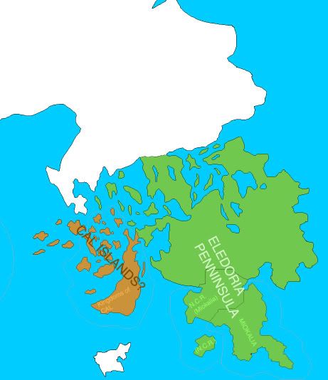 (sorry the image may have ended up enormous) |
|
|
|
Post by miokalia on Jul 25, 2006 0:52:50 GMT -5
Okay. So I've been wanting to do this for a while now. But I recently got just bored enough to get around to it: A population cartogram of the Federation. (Nations are proportioned based on their reletive populations.)  yeah, I know not all the nations are on there, just the ones I could find practical data for. |
|
|
|
Post by The Union of Tinis on Jul 25, 2006 21:46:15 GMT -5
That's pretty slick. May I ask how ye created thine map-o-cartogram?
|
|
|
|
Post by miokalia on Jul 25, 2006 23:06:06 GMT -5
First, I found the populations of all the nations I could find populations for. (Using the forum RP populations primarily). Then I made a scale: 1 square=10 million. For the larger nations, I modified the scale so that they would fit on the map. The larger nations' scale is less quantitative, but more reletive.
Then I drew the nations so that they took up the number of squares that represented their population, rather than their land-area (like a normal map would do). Then I scanned that in. Then I colored it. Then I removed the goofy pencil lines and threw a mosaic filter over it to make the edges less hand-drawn looking.
I've been thinking of doing one that represents species, but I'm not really sure how I'm going to do that yet.
|
|
|
|
Post by Sehvekah on Nov 20, 2006 20:16:24 GMT -5
Well, I've been here long enough, I figure it's probably about time to start getting involved, and to that end, I'm starting by putting my place on the map. img244.imageshack.us/img244/3135/ffmappolzy9.gifThe light grey area is the approxamate location of Sehvekah. And yes, I know it's big, but I haven't finalized anything design wise, so it's open to change if necessary(mostly along the northern border). |
|
|
|
Post by The Union of Tinis on Nov 20, 2006 20:33:17 GMT -5
I can do the map work if you like. What sort of terrain would you like? I was kind of leaning towards the northern boarder area being more desert like but options are always open.
|
|
|
|
Post by Sehvekah on Nov 21, 2006 0:25:24 GMT -5
If it's not too much trouble, that'd be great. As for the northern desert, that's exactly what I was thinking(I made sure to look at all the maps to get an idea of the climates of the various areas). The northern border is rather ill defined for that reason, as it's inhospitable and largely devoid of any useful resources. I know the southern border has mountains, and there's also a second range that runs roughly parallel to the south/east coast, 50-300 miles inland, disappearing into the desert at the north, and merging with the southern range at the other end. The east coast is largely Mediterranean in climate toward the north, becoming cooler to wards the south. There's not a whole lot of rainfall, but plenty of rivers from the mountains, desalination plants along the coast, and proximity to the sea keeps it from getting too dry. This contains the bulk of the nations farmland, fish hatcheries and other food production centers. The eastern peninsula contains the largest nature preserve in the nation, largely tropical forests, though there's some old and well worm mountains(there was once a range running through the center line, but it's eroded down enough it's hard to see that), marshland and a significant amount of beaches. At the north, a river runs west from the mountains and to the sea. It starts out small, but quickly grows to a size permitting reasonable shipping lanes to open, especially to wards the last third of it's length. This area(from about 30-50 miles north of the city mentioned below, to about 200 miles north) would normally be savanna, but has been taken over by heavy industry, military training centers, nuclear research facilities and the Celestus Facility(about half way between the east & west coasts, and as far north as possible without being in the desert) and associated support and supply centers. The western coast, from 30-50 miles south of the river, is one huge city. Climate wise, the area if fairly temperate, warmer in the north(summer highs averaging 95F) but cooling the farther south one moves, with moderate to significant amounts of rainfall throughout, though the coastline and the foothills of the mountains get most of it. Toward the south(though obviously north and west of the mountains) are a tangle of lakes and rivers, the largest of which are clearly visible from space. Though none are individually large enough of rival even the smallest of the Great Lakes, collectively they hold at least as much fresh water, and provide a similar role, providing resources, travel and commerce both locally and to the nation as a whole. In the remaining central area lay the massive wastelands. Though with scattered bands of hills, lakes and rivers, they were largely flat and lush. Were it not for the abundance of valuable minerals to be mined, they would have become the largest unbroken mass of farmland in the region. As is, only along the southern edge, and for 10 or so miles around the rivers and lakes within the area are there any farms left. The rest has been repeatedly drilled, mined and reprocessed again and again, leaving it nearly as barren and inhospitable as the northern deserts. Let me know if you need any other info, or something I said doesn't make any sense. |
|
|
|
Post by Kingdoms of Cal on Nov 21, 2006 17:08:58 GMT -5
Just a wee note, the peninsular is cal, the islands off the west coast are the Isles of Sae and the island off the east coast is inleef.
Just a wee note.....the peninsular contains the kingdoms of drew, Teu and Teer, the baronies and the principality of Tel also reside on the peninsular.
The state is The Royal Commonwealth of Kingdoms of Cal....Or Kingdoms of Cal (short name)...The full name is The Royal Commonwealth Of Kingdoms, Principalities And Baronies Of Cal And Sae.
The Far north of the peninsular is the mountains of alba, a small puppet state controlled by the commonwealth purely for use at the UN.
|
|
|
|
Post by miokalia on Nov 21, 2006 18:00:28 GMT -5
This deatail about Cal should be added to the map, including Alba.
Because I had no idea where these places were before and it would be tremendously usefull to have that for RP purposes.
Hey Cal, you should make a provincial map or something. Or if you want, describe it and one of us will make it.
|
|
|
|
Post by Erenmor on Nov 21, 2006 18:33:11 GMT -5
Would be nice to know where Thack is too, on that note...
|
|